


Description
Finally, a map made by climbers for climbers
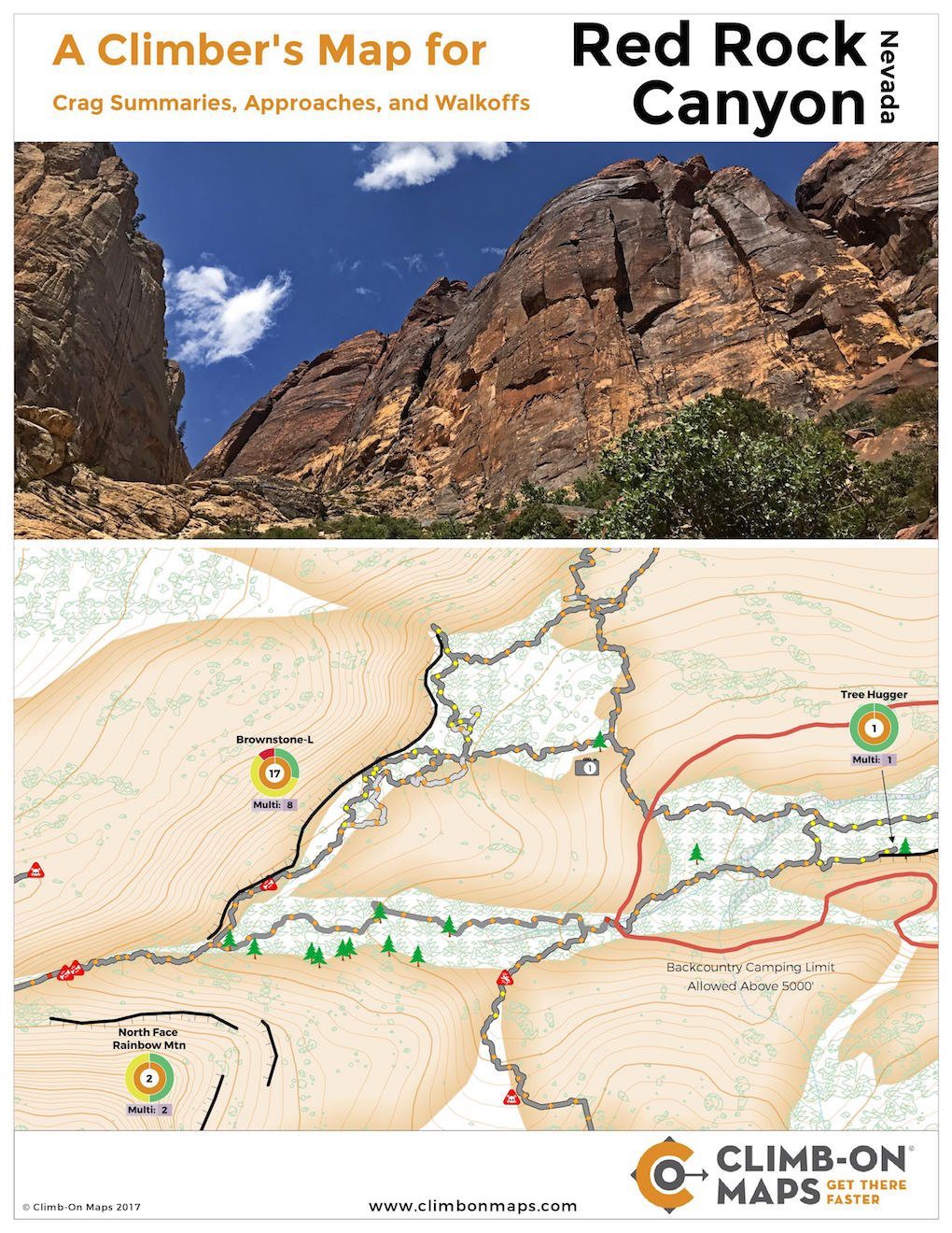
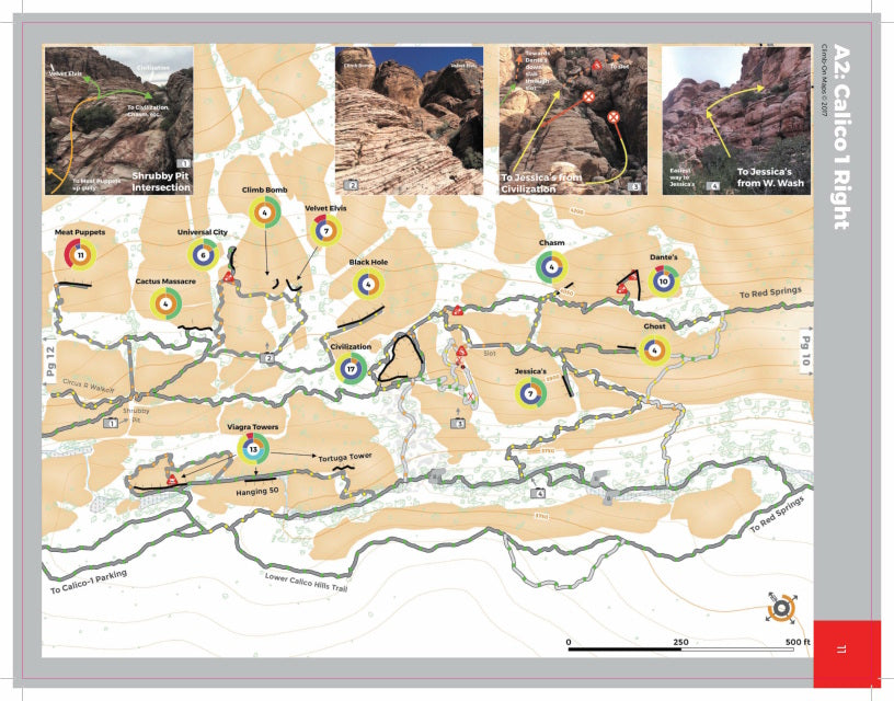
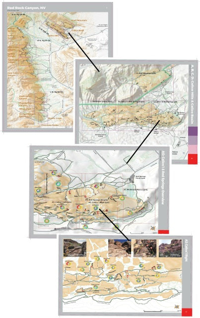
Get climbing faster! Picks up where guidebooks and Mountain Project leave off. Very detailed climbing approach and walk-off trail maps for Red Rock Canyon, NV. In addition to finding your way around Red Rock climbing areas inside and outside of the Scenic Loop, use the map to easily plan your day with color-coded crag summaries. Want to do some difficult climbs and crag hopping? Look for the red (5.12+) and blue (sport) circles. Then easily find crags next to each other, see how to get from one crag to the next, and see how difficult the approach is. Want to climb easy trad ? Look for green (5.9 & under) and orange (trad) circles with a purple table. All trails have difficulty ratings and show exposure points. Labeled orientation photos from the ground help ID crags and clarify confusing points.
Get climbing faster! Picks up where guidebooks and Mountain Project leave off. Very detailed climbing approach and walk-off trail maps for Red Rock Canyon, NV. In addition to finding your way around Red Rock climbing areas inside and outside of the Scenic Loop, use the map to easily plan your day with color-coded crag summaries. Want to do some difficult climbs and crag hopping? Look for the red (5.12+) and blue (sport) circles. Then easily find crags next to each other, see how to get from one crag to the next, and see how difficult the approach is. Want to climb easy trad ? Look for green (5.9 & under) and orange (trad) circles with a purple table. All trails have difficulty ratings and show exposure points. Labeled orientation photos from the ground help ID crags and clarify confusing points.
- 64 loose pages, 8.5"x11" waterproof/tearproof pages (32 pages, 2-sided) with and detailed maps. Grab the pages you need and go!
- Labelled orientation photos from the ground.
- Detailed map scale is 1:2,500! (Most maps are 1:24,000)
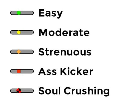
- Trails are marked with difficulty level and points of exposure (> ~ fall)
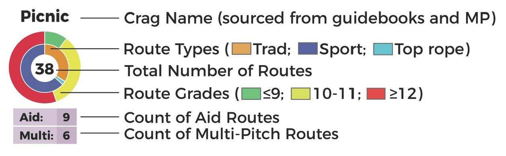
- Crag summaries (total number of climbs, distribution of climb types and grade, number of and aid climbs).
- Alphabetized crag finder for over 300+ crags/walls/areas
- Lot's of orientation photos from angles you will see from the trail!
- Approaches and non-rappel walk-offs
- Trail difficulty ratings (easy, moderate, strenuous, ass kicker, )
- Points of exposure (broken bones, major damage, Rest In Peace - RIP)
- Crag summaries (distribution of climb types, grades, number of multi-pitch and aid climbs)
- Walking-accessible top rope access noted
- Weight 218 grams
- Made in
- For more details visit climbonmaps.com.
You may also like
Recently viewed